TEP-tiedote 2/00
- Etusivu
- Etusisäsivu
- TEP-Tekniikka Elämää Palvelemaan
- TEP Mahdollisuuksien torilla
- Mihin rahat riittävät?
- Vieraana Mali-Folkecenterin johtaja
- Mali-Folkecenter
- Paraboloidikeitin Satu Hassille
- Keitinprojektin tilanne
- Vieraana Professori Aitken
- TEP - Säännöt
- International Trends in Renewable Energy
- INES Newsletter 28
- TEPin julkaisuja
- Takasisäsivu
- Takasivu
Mali-Folkcenterin johtaja TEPin vieraana
| MALI-FOLKECENTER for Renewble Energy on Tanskan tuella Malissa toimiva keskus, joka pyrkii levittämään soveltuvaa teknologiaa Maliin, pääasiassa maaseudulle ja maaseutukyliin. Keinoina ovat erilaiset teknologiaprojektit sekä tiedonlevitys. Lue lisää seuraavilta sivuilta. | MALI FOLKECENTERin johtaja Ibrahim Togola kävi TEPin hallituksen kokouksessa kertomassa keskuksen kuulumisia ja myös sen toimintatavasta siltä varalta, että TEP haluaisi avata samantapaisen keskuksen jonnekin muualle. Ibrahim oli myös kiinostunut yhteistyöstä TEPin kanssa, kunhan sopiva yhteistyömuoto löytyy. TEPin hallitus piti toki arvokkaana tällaista tiedotustoimintaakin. |
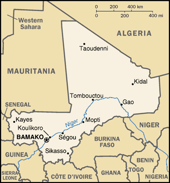
PERUSTIETOJA MALISTA
Tässä TEPin jäsenille pieni tietopaketti Malista. Osa englanniksi, vaikka Malin virallinen kieli onkin ranska.
 |
 |
|
Valtiomuoto: tasavalta Pinta-ala: 1 240 192 km2 Pääkaupunki: Bamako (n. 1,2 miljoonaa asukasta) Asukasluku: 11,1 miljonaa (1996) Virallinen kieli: ranska Lippu: Kolme tasapaksua pystysuoraa raitaa; vihreä-keltainen-punainen. |
Uskonnot: islamilaisia n. 90%, lisäksi perinteisiä afrikkalaisia luonnonuskontoja sekä pieni kristitty vähemmistö Aika: -2 h Suomen aikaan verrattuna Kansallispäivä: 22.9. (Itsenäistyi Ranskan alaisuudesta 1960) Keskilämpö: Bamako tammikuu +23 °C, kesäkuu+35 °C Rahayksikkö: Malin frangi BKT asukasta kohti: 270 US dollaria (1993) |
|
GEOGRAPHY: Mali is a landlocked republic, sharing borders with Mauritania,
Algeria, Burkina Faso, Côte d'Ivoire, Guinea, Niger and Senegal. It is a
vast land of flat plains fed by two major rivers, the Senegal on its western
edge and the great River Niger. On its journey north the Niger converges
with the River Bani, and forms a rich inland delta, the marshlands of the
Macina, stretching for some 450km (280 miles) along the river's length, in
some places 200km (124 miles) wide. The central part of the country is arid
grazing land, called the Sahel, which has suffered great drought. At Timbuktu
the Niger reaches the desert and here it turns first to the east, then to the
southeast at Bourem, where it heads for the ocean. In the desert, near the
Algerian and Niger borders in the northeast, the Adrar des Iforas massif
rises 800m (2625ft). The north of the country is true desert except for the
few oases along the ancient trans-Sahara camel routes. Tuaregs still live
around these oases and camel routes. Further south live the Peulh
cattle-raising nomads. The majority of the population lives in the savannah
region in the south. The peoples of this region comprise Songhai, Malinke,
Senoufou, Dogon and the Bambara (the largest ethnic group).
GOVERNMENT: Republic. Gained independence from France in 1960.
Head of State: President Alpha Oumar Konaré since 1992.
Head of Government: Prime Minister Ibrahim Boubacar Keďta since 1994. |
Life expectancy at birth: total population: 47.5 years male: 46.09 years female: 48.96 years (1999 est.) Literacy: definition: age 15 and over can read and write total population: 31% male: 39.4% female: 23.1% (1995 est.) Economy—overview: Mali is among the poorest countries in the world, with 65% of its land area desert or semidesert. Economic activity is largely confined to the riverine area irrigated by the Niger. About 10% of the population is nomadic and some 80% of the labor force is engaged in farming and fishing. Industrial activity is concentrated on processing farm commodities. Mali is heavily dependent on foreign aid and vulnerable to fluctuations in world prices for cotton, its main export. In 1997, the government continued its successful implementation of an IMF-recommended structural adjustment program that is helping the economy grow, diversify, and attract foreign investment. Mali's adherence to economic reform, and the 50% devaluation of the African franc in January 1994, has pushed up economic growth. Several multinational corporations increased gold mining operations in 1996-98, and the government anticipates that Mali will become a major Sub-Saharan gold exporter in the next few years. Annual growth thus may fall in the 5% range in 1999-2000, and inflation held to 5% or less. GDP-composition by sector: agriculture: 49% industry: 17% services: 34% (1995) Electricity—production by source: fossil fuel: 21.88% hydro: 78.12% nuclear: 0% other: 0% (1996) Agriculture—products: cotton, millet, rice, corn, vegetables, peanuts; cattle, sheep, goats |